I used to think smart cities were mostly about apps and sensors on lampposts. Then I realized none of it works well if the road under your tires is still stuck in the 1980s.
Smart cities need smart roads because traffic data, self-driving cars, delivery robots, and emergency response all depend on what happens at ground level. In a place like asphalt Denver, that means using connected sensors, better materials, and smarter maintenance so the pavement itself becomes part of the tech stack, not just a dead surface you drive on.
Why the road itself matters more than the shiny tech
Most people think about smart cities and picture drones, smart traffic lights, or those dashboards that show real‑time congestion. That is all useful, but if you peel it back a bit, almost everything still starts at the road surface.
Your car, whether it is human‑driven or automated, only has three things to work with:
- The shape of the road
- The friction of the surface
- The markings and signs
Everything else is built on top of that. Any sensor, AI model, or control system needs those basics to be reliable.
Smart infrastructure is not only about software; it is about what your wheels touch every day.
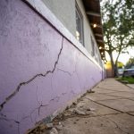
If the asphalt cracks, floods, or loses paint, all the clever tech has to compensate. That is hard. You can throw machine learning at bad data, but it will still be bad data. So the boring part of the city, the black surface nobody notices when it is fine, suddenly becomes the real foundation.
In a city like Denver, with freeze‑thaw cycles, UV exposure, and heavy traffic, the road is under constant stress. You get:
- Potholes forming after winter
- Ruts in bus lanes
- Faded lane markings that confuse both humans and cameras
- Drainage problems that leave puddles where they should not be
If you want smart mobility, that list is not just a maintenance problem. It is a data problem and a safety problem.
What “smart roads” actually means
The phrase “smart road” sometimes sounds like marketing. So it helps to make it concrete. At a very simple level, a smart road usually combines three layers:
- Better materials and structure
- Embedded sensing and connectivity
- Data feedback into maintenance and traffic systems
You do not need all three at once to be useful, and you definitely do not need sci‑fi features like roads that charge cars wirelessly. In fact, most cities will probably never need that.
I think of smart roads more like this:
A smart road is one that knows its own condition and can “talk” to the systems that depend on it.
Sometimes that “talk” is simple: a sensor notices water in a low spot and pings a maintenance ticket. Sometimes it is more advanced: a connected plow changes route because pavement temperature ahead is lower than expected.
So when people push smart city plans that focus only on apps or vehicle tech, they are skipping the step where the road finally gets a voice.
Key building blocks of a smart road
To make this more practical, you can break it down into a few features that matter for cities like Denver.
| Smart road feature | What it does | Why it matters in a tech context |
|---|---|---|
| Embedded sensors | Measure temperature, traffic volume, weight, moisture | Feeds live data to traffic control and maintenance systems |
| Connected signals & signs | Adapt timing, speed limits, and priority to actual conditions | Reduces congestion and supports connected vehicles |
| Machine‑readable markings | Higher contrast and consistent patterns for cameras | Improves reliability of driver‑assist and autonomous systems |
| Predictive maintenance | Uses data to plan resurfacing before failure | Reduces unexpected closures and repair costs |
| Integrated drainage & snow management | Monitors ice risk, pooling water, and plow progress | Supports safer routing and fewer weather‑related crashes |
None of that is magic. It is just tech people already know, stitched into asphalt and paint.
Why Denver is a perfect testbed for smart roads
I do not live in Denver, but I have been through it enough times to notice two things: the weather can swing hard, and people drive a lot. That alone makes the city a good stress test for any road tech.
Here is what makes Denver interesting for smart roads:
- Freeze‑thaw cycles that punish cracks and joints
- High UV exposure that fades markings faster than in cloudier regions
- Growing population and traffic around employment hubs
- Mix of old downtown streets and newer suburban networks
- Snow and deicing chemicals that attack pavement structure
For a tech‑minded reader, this is almost like a hostile environment lab. If sensors, materials, and data workflows can survive here, they have a better chance in gentler climates.
There is also a policy angle. Colorado has been open to connected vehicle pilots, digital infrastructure grants, and collaboration between cities and private companies. That does not solve funding gaps by itself, but it gives local planners more room to experiment.
Denver does not need to be the most futuristic city; it just needs to prove that smarter roads actually reduce crashes, delays, and maintenance costs in a harsh real‑world setting.
If it can show that, other cities will borrow the same playbook.
The link between asphalt condition and smart mobility
Tech people love clean abstractions. In transport, it is easy to think in terms of vehicles and algorithms. But if you talk to anyone who works with road data, they will quietly point back to the surface condition.
Take three common use cases: driver assistance systems, shared scooters, and delivery vehicles.
1. Driver assistance and autonomy
Modern cars depend on:
- Clear lane markings for lane keeping assist
- Stable friction for ABS and stability control
- Predictable road edges and curbs for sensor fusion
If markings are faded, cameras lose track more often. If potholes are frequent, vehicles swerve, which confuses path prediction. These small failures add up:
| Road issue | Impact on human drivers | Impact on driver assistance / autonomy |
|---|---|---|
| Faded lane paint | More drift, late lane changes | Loss of lane reference, system disengagements |
| Standing water | Hydroplaning risk | Sensor noise, misclassified reflections |
| Potholes | Vehicle damage, collision risk when swerving | Unpredictable paths, harder control models |
| Snow‑covered markings | Confused lane choices | Camera blind to lines, reliance on maps |
If you want autonomous shuttles to work on normal streets, not just carefully curated test routes, then the maintenance budget and strategy around asphalt matters as much as any update to self‑driving software.
2. Micromobility and soft modes
Scooters, bikes, and e‑bikes react to tiny surface defects that car drivers barely notice. A crack that looks minimal in a car can flip a scooter at the wrong angle.
So a smart road for micromobility might need:
- Smoother joints between asphalt and concrete patches
- Better lighting around surface defects
- Data from scooters themselves about rough segments
If a scooter fleet keeps reporting high vibration on a specific block, that is a real‑time maintenance hint. But the road agency needs a way to catch that signal and fold it into its workflow.
3. Delivery and logistics
Freight companies in a city like Denver care a lot about predictable travel times and reduced wear on heavy vehicles. Potholes and ruts cost money.
Smart roads can help routing software avoid weak sections, or at least reduce loads at certain hours. But again, that only works if you have some kind of live picture of surface condition and subgrade stress.
This creates a feedback loop:
- Heavy trucks stress routes
- Sensors see early distress patterns
- City changes truck routes or times
- Damage spreads more slowly
That is not glamorous work, but it is the sort of quiet change that tech readers tend to appreciate once they see the data side.
From reactive repairs to predictive maintenance
Most cities still work on a reactive model. A pothole appears, someone complains, a crew patches it. It is like bug tracking with no logging or monitoring; you only know about the bug when a user screams.
For smart roads, you need something closer to observability.
Here are some realistic data sources a Denver‑style road network can use:
- Pavement condition sensors at key points
- Smartphone accelerometer data (aggregated and anonymized)
- Vehicle telemetry where drivers opt in
- Camera scans from buses or garbage trucks
- Thermal sensors to track freeze‑thaw risk
If those data sources feed a central model, the road manager can see where problems are likely to appear in the next season.
Predictive maintenance for asphalt is not about knowing the exact day a crack forms; it is about having a 6 to 18 month window where repair costs are much lower.
For a tech reader, this is where typical tools apply:
- Time‑series forecasting for distress progression
- Computer vision on pavement images
- Routing optimization for work crews
- Simple AR interfaces to guide field inspection
There is a bit of hype in this space. Some pitches oversell AI as if it can fix budget gaps. It cannot. But it can help answer boring questions like:
- Which 5 percent of the network should we treat this year to avoid 20 percent of future failures
- Where is sealcoating most cost effective compared to full resurfacing
- Which streets need upgraded markings first to help advanced driver systems
If a city like Denver can run that kind of pipeline and then show the cost savings, that becomes a template for others.
Smart roads and climate resilience in Denver
Climate is a huge wildcard for roads. In Colorado, hotter summers, intense rain bursts, and odd snow patterns are slowly changing stress on asphalt.
Some of the responses are low tech:
- Better drainage design so heavy storms do not chew up edges
- More frequent sealcoating cycles in high UV zones
- More careful selection of asphalt mixes for different corridors
The “smart” part comes when you connect weather data, sensors, and material choices.
For example:
| Input data | Action on the ground |
|---|---|
| Forecast of repeated freeze‑thaw events | Preemptive crack sealing on vulnerable sections |
| Longer extreme heat streaks | Switch to more rut‑resistant asphalt mixes on heavy routes |
| Heavier summer storms | Rebuild drainage in flood‑prone intersections |
If you are into data, there is an interesting modeling challenge here: how to connect long‑term climate projections with short‑term maintenance planning, when budgets are political and often yearly.
I am not fully convinced every city is ready for that complexity yet, but Denver at least has the weather signals that push the topic forward.
Smart parking lots and private roads as part of the picture
When people talk about roads, they usually think only of public streets. In a metro area, a huge share of asphalt sits in:
- Parking lots around shopping areas and offices
- Private campus roads
- Industrial access lanes
From a smart city perspective, these spaces matter just as much:
- They are where many crashes and fender‑benders actually happen
- They control how people arrive at transit or shared bikes
- They affect drainage and heat in a neighborhood
A “smart” parking surface in Denver might include:
- Clear striping that cameras in cars and robots can read easily
- Surface sensors for occupancy and snow conditions
- Better routing for pedestrians through the lot
- Surface treatments that reduce glare and improve camera contrast
If tech readers are building apps around parking or curb management, all of that matters. You can have a perfect digital map of spaces, but if the physical paint is wrong or invisible, human behavior will not match your model.
Standardization: teaching roads to speak the same language
One quiet problem in smart road work is the lack of standard “vocabulary.” Different cities use slightly different marking patterns, sensor types, and data formats.
For connected vehicles, that is messy. A car that leaves Denver for another city should not have to “guess” what a lane marking means.
So there is a push to make:
- Standard marking patterns with machine‑readable rules
- Common data schemas for pavement condition
- Shared vocabularies for digital street maps
It reminds me a bit of early networking history, where each vendor had its own ideas until protocols settled down.
Smart roads in Denver that follow emerging standards can hook into national and global systems much more directly. That helps with:
- Interoperability across car brands
- Regional traffic coordination
- Shared research and benchmarking
This part feels dry, but if you are used to API design and schema management, the parallels are obvious.
Privacy, equity, and the messy human layer
There is one area where I think some smart road visions go too far: data hunger. When people talk about pulling data from every car, scooter, and phone, privacy flags go up for good reason.
Smart cities do not need to harvest everything. You can get most of the value from:
- Coarse, anonymized aggregates about speed and vibration
- Opt‑in data from fleets that have a clear business benefit
- Static sensors that measure the environment, not people
Road work also has an equity angle that tech sometimes forgets. If data is strongest where people already use the latest devices and services, then predictive maintenance might favor those neighborhoods.
There is a risk here: the streets with less data might get less care, which reinforces existing gaps.
I think cities like Denver will need clear rules on:
- Minimum inspection levels for all areas, not just data‑rich ones
- Open access to certain non‑personal road metrics
- Simple dashboards that residents can understand and question
That last part matters. If smart roads appear to only help commuters in certain corridors, support will fade quickly.
What tech people can actually do with this
If you work in software, data, or hardware, this topic is not just abstract. There are quite a few practical directions:
- Build better tools for surface condition mapping using low‑cost sensors
- Help road agencies clean and visualize their existing data
- Contribute to open standards for digital road features
- Design vehicle systems that are more tolerant of real‑world pavement quirks
One honest limitation: many road agencies are stretched. They do not need another dashboard for its own sake. They need simple, maintainable systems that connect to how crews actually work.
A smart road project that saves one hour per week for every field crew probably matters more than a fancy 3D city map that nobody in operations opens after the pilot.
So if you build tools in this space, anchoring them in actual workflows and budgets is key. That sounds obvious, but a lot of pilots still get that part wrong.
Smart roads inside asphalt: a quick Q&A
Q: Do we really need sensors inside the road, or can we just use vehicle data?
A: Vehicle data is powerful, but not everyone shares it, and it can be noisy. Embedded sensors give a stable reference that helps calibrate and cross‑check other sources. A mix is usually stronger than either alone.
Q: Is this mostly about helping self‑driving cars?
A: No. Better surface condition and markings help every driver, cyclist, and pedestrian. Autonomous systems are just more sensitive to certain defects, so they highlight issues that humans sometimes tolerate for too long.
Q: Does smart road work always mean higher costs?
A: Short term, some upgrades cost more, yes. Over a 10 to 20 year span, well‑timed maintenance and better materials often reduce total spending, because you avoid full rebuilds that come from neglect.
Q: Where should a city like Denver start?
A: A focused corridor is usually smarter than a citywide rollout. Pick a route with frequent buses, heavy traffic, and weather stress. Add basic sensing, improve markings, adjust maintenance, and measure crash and delay changes over a few years.
Q: Is this all too complex for most road agencies?
A: Parts of it might be, at least right now. But starting small with better data collection, simple condition scores, and clearer markings is already within reach. The “smart” label is less important than consistent, visible gains in safety and reliability.